LiDAR-based tree crown mapping in ArcGIS Pro using R-stats | burdGIS

Discover the power of integrating LiDAR data with R and ArcGIS Pro in this comprehensive guide to Tree Crown Mapping. Whether you're a GIS professional, ecologist, or a student diving into spatial analysis, this tutorial offers valuable insights and practical steps.
What You'll Learn:
LiDAR Data Analysis: Uncover the secrets of LiDAR data as we delve into its application for environmental mapping.
RStats in Action: Watch how R integrates seamlessly with ArcGIS Pro for advanced spatial analysis.
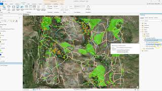
Tree Crown Delineation: Learn the stepbystep process of tree crown mapping, a critical tool for forest management and ecological studies.
Backward Approach Tutorial: In a unique twist, we start from the end result and work our way back to the basics perfect for those short on time but keen on results. Let me know if you like this format.
Links
Code used in the video:
https://github.com/Ojaybee/treetopd...
Pennsylvania working group (original code):
https://www.srbc.gov/pennsylvaniaele...
ForestTools github repo:
https://github.com/andrewplowright/F...
DEFRA LiDAR download:
https://environment.data.gov.uk/survey
00:00 Introduction
00:26 Run the tool
01:31 Build the tool
04:11 Code for the script
05:13 Troubleshooting
06:26 ArcGIS Pro R bridge
07:54 Data sources
If you enjoyed this video you can support the channel and buy me a coffee using this link:
https://paypal.me/burdGIS
Visit our site
https://www.burdgis.com
Take an online GIS course
https://www.udemy.com/course/anintro...
Find us on facebook
/ burdgis
Use coinbase as the home for your cryptocurrency:
https://www.coinbase.com/join/5c6d098...