LiDAR LAStools with QGIS. Create DEM and Contour lines ✔️✔️✔️

To learn more about Geo RGB, visit us at:
https://giscourse.online
Contact us at:
[email protected]
▶ LiDAR LAStools with QGIS. Create DEM and Contour lines.
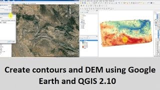
This minicourse consist in 3 video tutorials. In the first one, you are going to learn how to create a Digital Elevation Model (DEM) with QGIS using data from Google Earth. In the second one, you are going to learn how to use LASTool to process LiDAR data to create a DEM with QGIS. Also, you are going to see how to get the contour lines from both models. The third one is going to be a comparison between the two models and we will have a discussion about the accuracy of the ground elevation from Google Earth data.
▶ What you are going to learn in Part 2:
✔ Where downloading the LAStools
✔ Setting up LAStools in QGIS 3.10 A Coruña
✔ Download LiDAR data and checking metadata
✔ Analyzing LiDAR data: lasinfo
✔ Visualizing LiDAR data 3D: lasview
✔ Creating DEM: las2dem and blast2dem
✔ Visualizing DEM 3D
✔ Contour lines extraction
✔ Labeling and symbology
▶ Links of interest:
https://rapidlasso.com/lastools/
https://opendata.countygp.ab.ca/
https://www.arcgis.com/index.html


![How to Download Digital Elevation Models (DEM) in QGIS [OPENTOPOGRAPHY]](https://i.ytimg.com/vi/FeM86Gz40_k/mqdefault.jpg)