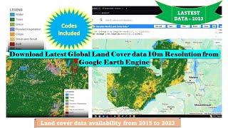
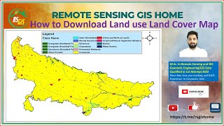
LULC for India data Download and create shapefile

In this video I have shown you the sources and steps to extract Landuse and Landcover (LULC) data for three decades.
In general,
This data set provides land use and land cover (LULC) classification products at 100m resolution for India at decadal intervals for 1985, 1995 and 2005. The data were derived from Landsat 4 and 5 Thematic Mapper (TM), Enhanced Thematic Mapper Plus (ETM+), and Multispectral (MSS) data, India Remote Sensing satellites (IRS) Resourcesat Linear Imaging SelfScanning Sensor1 or III (LISSI, LISSIII) data, ground truth surveys, and visual interpretation. The data were classified according to the International GeosphereBiosphere Programme (IGBP) classification scheme.
Land cover maps were produced using a process that began with the classification, visual interpretation, and data verification of the 2005 imagery (using ground truth data) to produce a 2005 national LULC map. The 1995 Landsat images were overlaid onto the 2005 map and polygons were traced where LULC change had occurred. The process was applied to the 1985 imagery using the 1995 map as the starting reference. Onscreen image interpretation was used to assess the maps (Roy et al., 2015; Meiyappan et al., 2016 in review). The minimum mapping unit was 2.5 hectares.
There are three data files in GeoTIFF (.tif) format with this data set; one file each for 2005, 1995, and 1985. A companion file lists the specific satellite resources used as the basis for the LULC classifications.
Pixel values / Classification or Grid codes in ArcGIS
1 Deciduous Broadleaf Forest
2 Cropland
3 Builtup Land
4 Mixed Forest
5 Shrubland
6 Barren Land
7 Fallow Land
8 Wasteland
9 Water Bodies
10 Plantations
11 Aquaculture
12 Mangrove Forest
13 Salt Pan
14 Grassland
15 Evergreen Broadleaf Forest
16 Deciduous Needleleaf Forest
17 Permanent Wetlands
18 Snow & Ice
19 Evergreen Needleleaf Forest
Fore downloading data and more information visit:https://daac.ornl.gov/VEGETATION/guid...
For more such videos please subscribe to this channel and if you like the video give a like and comment for any doubts or for new videos on certain topics.
Good luck...…….!