15 Free YouTube subscribers for your channel

Make a stunning shaded landcover maps woth ESRI LULC Data

How to Create Beautiful Land Use and Land Cover Maps with ESRI Living Atlas LULC Data.
Abdou SENE
Timecode:
00:00 Expected Result
00:26 Downloading Data from ESRI
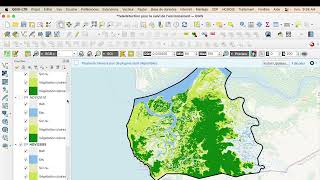
01:18 Creating a QGIS Project and Importing Data
02:27 Extracting the Working Area and Clipping the Raster
04:12 Downloading the DTM
05:50 Creating the Shade/Hillshade
07:34 Adjusting the Land Use and Land Cover Legend
09:22 OntheFly Fusion of the 2 Rasters
11:55 Drop Shadow
14:35 Explicit Legend
17:00 ChatGPT? (At Our Own Risk)
17:21 Grazing is More Suitable
18:53 Map Layout
21:15 Call to Action
#cartography #30daymapchallenge #qgis #map #arcgis #gismaps #world #gis #worldmap


Recommended


