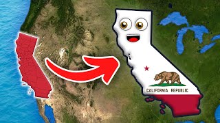
MAP OF CALIFORNIA !

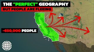
hello hello my friends. this ia a map of beautiful california..California is the thirdlargest state in the United States in area, after Alaska and Texas. California is one of the most geographically diverse states in the union and is often geographically bisected into two regions, Southern California, comprising the ten southernmost counties, and Northern California, comprising the 48 northernmost counties. It is bordered by Oregon to the north, Nevada to the east and northeast, Arizona to the southeast, the Pacific Ocean to the west and shares an international border with the Mexican state of Baja California to the south..
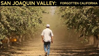
In the middle of the state lies the California Central Valley, bounded by the Sierra Nevada in the east, the coastal mountain ranges in the west, the Cascade Range to the north and by the Tehachapi Mountains in the south. The Central Valley is California's productive agricultural heartland.
Divided in two by the SacramentoSan Joaquin River Delta, the northern portion, the Sacramento Valley serves as the watershed of the Sacramento River, while the southern portion, the San Joaquin Valley is the watershed for the San Joaquin River. Both valleys derive their names from the rivers that flow through them. With dredging, the Sacramento and the San Joaquin Rivers have remained deep enough for several inland cities to be seaports.
The SacramentoSan Joaquin River Delta is a critical water supply hub for the state. Water is diverted from the delta and through an extensive network of pumps and canals that traverse nearly the length of the state, to the Central Valley and the State Water Projects and other needs. Water from the Delta provides drinking water for nearly 23 million people, almost twothirds of the state's population as well as water for farmers on the west side of the San Joaquin Valley.
Suisun Bay lies at the confluence of the Sacramento and San Joaquin Rivers. The water is drained by the Carquinez Strait, which flows into San Pablo Bay, a northern extension of San Francisco Bay, which then connects to the Pacific Ocean via the Golden Gate strait.
The Channel Islands are located off the Southern coast, while the Farallon Islands lie west of San Francisco.
The Sierra Nevada includes the highest peak in the contiguous 48 states, Mount Whitney, at 14,505 feet.. thanks for listening. please subscribe for the best maps and for the love of california. The range embraces Yosemite Valley, famous for its glacially carved domes, and Sequoia National Park, home to the giant sequoia trees, the largest living organisms on Earth, and the deep freshwater lake, Lake Tahoe, the largest lake in the state by volume.
To the east of the Sierra Nevada are Owens Valley and Mono Lake, an essential migratory bird habitat. In the western part of the state is Clear Lake, the largest freshwater lake by area entirely in California. Although Lake Tahoe is larger, it is divided by the California/Nevada border. The Sierra Nevada falls to Arctic temperatures in winter and has several dozen small glaciers, including Palisade Glacier, the southernmost glacier in the United States.
The Tulare Lake was the largest freshwater lake west of the Mississippi River. A remnant of Pleistoceneera Lake Corcoran, Tulare Lake dried up by the early 20th century after its tributary rivers were diverted for agricultural irrigation and municipal water uses.[122]
About 45 percent of the state's total surface area is covered by forests,[123] and California's diversity of pine species is unmatched by any other state. California contains more forestland than any other state except Alaska. Many of the trees in the California White Mountains are the oldest in the world; an individual bristlecone pine is over 5,000 years old.[124][125]
In the south is a large inland salt lake, the Salton Sea. The southcentral desert is called the Mojave; to the northeast of the Mojave lies Death Valley, which contains the lowest and hottest place in North America, the Badwater Basin at −279 feet (−85 m).[7] The horizontal distance from the bottom of Death Valley to the top of Mount Whitney is less than 90 miles (140 km). Indeed, almost all of southeastern California is arid, hot desert, with routine extreme high temperatures during the summer. The southeastern border of California with Arizona is entirely formed by the Colorado River, from which the southern part of the state gets about half of its water.
A majority of California's cities are located in either the San Francisco Bay Area or the Sacramento metropolitan area in Northern California; or the Los Angeles area, the Inland Empire, or the San Diego metropolitan area in Southern California. The Los Angeles Area, the Bay Area, and the San Diego metropolitan area are among several major metropolitan areas along the California coast.


![9 Reasons Why People Are Leaving Sacramento California [And They Progressively Get WORSE!]](https://i.ytimg.com/vi/Ev5yQii33qg/mqdefault.jpg)