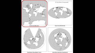
Map projections in GIS (theory)

This video explains what map projections are and how to use them in a practical way in geographic information systems. You'll learn about different projections, how to convert from degrees, minutes, seconds to decimal degrees, how to use EPSG codes, false norting, false easting, UTM and much more.
This video is part of IHE Delft OpenCourseWare. More free resources can be found at http://www.gisopencourseware.org
For an overview of our GIS courses and info on tailor made trainings and advise see our folder: https://www.unihe.org/sites/default/...
More information about the book "QGIS for Hydrological Applications Recipes for Catchment Hydrology and Water Management" by Kurt Menke and Hans van der Kwast can be found at the website of Locate Press: http://www.locatepress.com/hyd
IHE Delft and Nieuwland Geoinformatie offer an online course. It includes support from experienced trainers and you'll get the official QGIS certificate after completion. More info at: http://www.learninggis.com
Subscribe to the YouTube Channel for updates!