MASTERING DRONE IMAGE PROCESSING: USING GROUND CONTROL POINTS WITH AGISOFT METASHAPE PROFESSIONAL.

In this comprehensive tutorial series, we'll guide you through the process of processing drone imagery with Ground Control Points (GCPs) using the powerful Agisoft Metashape Professional software. As aerial survey professionals, mappers, and GIS specialists, the ability to accurately process and transform drone data into highquality 3D models and orthomosaics is essential for a wide range of applications, from construction monitoring and infrastructure analysis to environmental mapping and topographic surveys.
Learn the stepbystep workflow to import your drone imagery, establish and measure GCPs, and leverage the advanced photogrammetry algorithms in Metashape Professional to generate precise, georeferenced 3D point clouds, digital surface models (DSMs), and orthomosaics. Discover best practices for camera calibration, image alignment, and quality control to ensure your final outputs meet the highest standards of accuracy and reliability.
Whether you're new to drone surveying or looking to optimize your existing Metashape workflows, this channel will provide you with the knowledge and skills to unlock the full potential of your drone data. Subscribe now and take your aerial mapping capabilities to new heights!
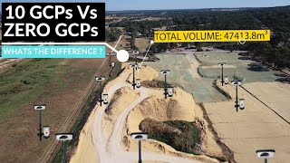
Learn how to enhance the accuracy of your aerial mapping projects with precise georeferencing techniques.
AGISOFT METASHAPE PROFESSIONAL INSTALLER
Download Link : https://www.agisoft.com/downloads/ins...
DRONE DATA PROCESSING SAMPLE
Download Link : https://drive.google.com/file/d/1mYks...
GROUND CONTROL POINT EXCEL DATE
Download Link : https://drive.google.com/file/d/19bxM...