Mastering Landsat 8 Data: Creating Band Composite u0026 Band Combinations in ArcGIS Pro

Dive into the world of remote sensing with our comprehensive tutorial on Generating Band Composites and Band Combinations using Landsat 8 data in ArcGIS Pro!
Landsat 8, with its multispectral capabilities, provides a wealth of information for analyzing Earth's surface. In this stepbystep guide, we'll walk you through the process of harnessing Landsat 8 data to create visually compelling and scientifically meaningful band composites and combinations.
What You'll Learn:
Understanding Landsat 8 Bands: Get acquainted with the different spectral bands and their unique characteristics.
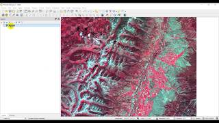
Creating RGB Composites: Learn how to combine specific bands to generate true color and false color composites for enhanced visualization.
Crafting Band Combinations: Explore the art and science of selecting bands to highlight specific features, such as vegetation, water bodies, and urban areas.
Dynamic Visualization: Master techniques to dynamically visualize changes over time using Landsat 8 imagery.
Tools and Techniques:
ArcGIS Pro Basics: A quick overview for beginners to ensure everyone can follow along.
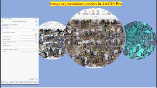
Image Analysis: Understand the fundamentals of image interpretation and analysis.
Band Arithmetic: Delve into the world of band arithmetic to perform customized band combinations.
Why Landsat 8?
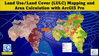
Discover the unique advantages of Landsat 8 data for monitoring environmental changes, land cover classification, and more.
Learn how to access and download Landsat 8 imagery for your specific area of interest.
Resources Mentioned:
Landsat 8 Data Access: • Download Landsat 8 images from EarthE...
Landsat 8 Band Combinations: https://gisgeography.com/landsat8ba...
Further Reading:
Explore additional resources and articles on advanced remote sensing techniques.
Join Membership to get access to perks & Support us
/ @terraspatial
Join the Terra Spatial Community:
Engage with fellow learners, share your experiences, and get support on our dedicated community forum.
Stay connected:
Subscribe to our Channel: / @terraspatial. .
Facebook: / terraspatial
Geosuite blog: https://geosuite.blogspot.com/
Join our community for ongoing discussions, tips, and tricks.
Ready to unlock the full potential of Landsat 8 data? Hit play and embark on a journey of creating stunning visualizations and extracting valuable insights from satellite imagery in ArcGIS Pro! Don't forget to like, share, and subscribe for more geospatial tutorials.✨
#bandcomposite #bandcombination #arcgispro #Landsat8 #remotesensing #gis #datavisualization #satelliteimagery #geospatialanalysis #truecolor #falsecolor