Mega 'Heat Dome' Incoming

Intense and prolonged heatwave expected next week for the Eastern US. The most intense heat will occur from the Ohio Valley to the MidAtlantic and Northeast from June 16 22nd.
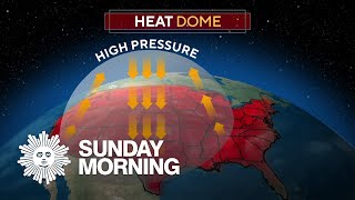
The cause is a massive upperlevel ridge of high pressure that parks itself near the MidAtlantic coast. Sinking, compressed air will bring multiple days of very extreme temperatures in the upper 90s and some 100s (35 38C) from Indiana to Massachusetts. Multiple daily record high temperatures are expected. 500mb geopotential heights will also be near record levels across the Northeast. Also, rapid onset drought could occur from the Ohio Valley to the MidAtlantic.
In addition, multiple days of thunderstorm clusters will occur along the northern periphery of the "heat dome". Places in the Upper Midwest could see many days of thunderstorm clusters. Severe storms and flash flooding will be a concern over the Dakotas, Minnesota, Iowa, and Wisconsin as these "ridge riders" move over the top of the ridge.
It's been years to even decades since some cities in this part of the country have had temperatures this hot. And with the potential for it to last for 6 days or longer, it could have serious impacts on infrastructure and people.
Stay safe everyone.
X/Twitter: @KvnCeleste