Sign In
Home
Popular
News
Popular now
New music
Cute animals
Trending today
Hot trailers
Popular music
Comedy clips
New tech
Popular sports
Learn new
The easiest way to skyrocket your YouTube subscribers
Animals
Babies
Beautiful
Cats
Creative
Cute
Dogs
Educational
Funny
Heartwarming
Holidays
Incredible
Inspirational
Interesting
Love
Music
Nature
Oops
Performance
Pranks
Science
Sports
Technology
Unexpected
Best Cat Humor
Dog Videos
Cover Song Competition
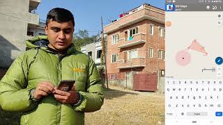
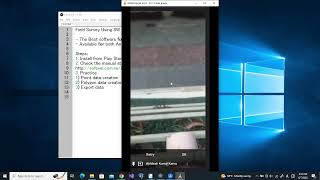
MGNREGA Assets Mapping/Geotags Using SWMaps for GIS based Planning
Back
Follow
This video demonstrated the assets mapping using SWMaps for MGNREGA works
posted by
Yasehm
[ f ] Share this video on Facebook
digitize village boundary for GIS based GP Plan: MoRDGIZ
How to Do Community Asset Mapping (ABCD) Using Google's My Maps
GIS Field Survey using QField (offline method)
How to integrate Geotagged or GPS data with GIS in Arc GIS Software
Collect GPS data using Mobile Phone || GPS survey using SW maps
Field Survey Using SW Maps (for Android and iOS)
what it’s like to work at GOOGLE…
What is GIS?
Learn GIS QGIS Full Course for Beginners (New for 2024)
OYE HOYE! #GhanaKasoota #shorts
NREGA WORKER NPCI MAPPING || NREGA NPCI PENDING LIST
Indigenous Australian Datathon 2022 Edition
How To Make GP Boundaries On Google Earth Pro | GIS Based Planning In MGNREGA
Geospatial Revolution / Episode One
Calculus at a Fifth Grade Level
Area Officer Application
Latitude and Longitude
Google Data Center 360° Tour
Recommended
Welsh Weather Presenter Breaks All Laws Of Pronunciation!
00:20
Depp Embodies Jack Sparrow For Disneyland Visitors!
00:57
Boy Can't Stop Admiring His Plaster Cast
01:11
How To Cook Iced iPhone 6
05:18
60 Minutes To Roll On The Floor Laughing Out Loud!
01:09
Taste Is Nothing, Thirst Is Everything!
02:11
Shop Me More, Shop Me Completely
05:47