Multi-band Image Visualization in Google Earth Engine || FCC || True Color || GEE: 05 || ITGIS

In this video I'm Covering Multiband image (LandSat) Visualization in Google Earth Engine (GEE).
Link of GEE:
https://earthengine.google.com/
CODE:
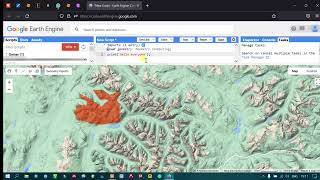
//Open Image
var image = ee.Image("LANDSAT/LC09/C02/T1_TOA/LC09_146050_20221224");
//Visualization Parameter
var vispara = {
bands: ['B5','B4','B3'],
min: 0,
max: 0.5
};
var vispara1 = {
bands: ['B4','B3','B2'],
min: 0,
max: 0.5
};
//MapCenter
Map.centerObject (image, 8);
//Display map
Map.addLayer(image,vispara,"FCC");
Map.addLayer(image,vispara1,"True Colour");
For other videos on my channel:
+++++++++++++++++++++++++
GEE Playlist:
• Google Earth Engine (GEE)
QGIS Video Playlist:
• QGIS Video Tutorials
ArcGIS Video Playlist:
• ArcGIS Video Tutorials
Google Earth Engine (GEE) Video Content:
GEE: 01 : Introduction and Explore Earth Engine
• Introduction and Explore Earth Engine...
GEE: 02 : Earth Engine Code Editor
• Earth Engine Code Editor || About Cod...
GEE: 03 : Basic Java Script Syntax
• Basic Java Script Syntax || Google Ea...
GEE: 04 : Single Band Image Visualization in Google Earth Engine
• Single Band Image Visualization in Go...
GEE: 05 : Multiband Image Visualization in Google Earth Engine
• Multiband Image Visualization in Goo...
GEE: 06 :Image Collection in Google Earth Engine
• Image Collection in Google Earth Engi...
#EarthEngine #GEE #MultiBandImageVisualization #ITGIS #GoogleEarthEngine #Landsat #RemoteSensing #Coding #JavaScript #JavaScriptInEarthEngine
If you have any queries please comment below. If you like my videos please subscribe to my channel for the latest update. Don't forget to Like, Share or Comment. Thanks for watching it.