Get YouTube subscribers that watch and like your videos

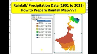
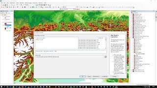
NDVI in ArcGIS || ArcGIS Tutorial || NDVI Landsat

NDVI in ArcGIS || ArcGIS Tutorial || NDVI Landsat
In this video the process of NDVI mapping from LANDSAT satellite images using arcgis software has been given
For more tutorial click on the links below:
Land use/land cover classification in ArcGIS: • Supervised Classification of LANDSAT ...
Supervised image classification : / watchv=ilt7vs7rshk&t=943s
How to download satellite imagery: • How to Download Satellite Imagery || ...
Digitization in ArcGIS: • How to digitize in ArcGIS || Digitiza...
Georeferencing in ArcGIS: • Georeferencing in ArcGIS || How to Ge...


Recommended