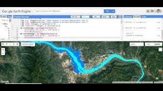
NDVI Map from Sentinel 2A Imageries in Google Earth Engine

Hello everybody, in this video we are going to learn to create a Normalized Difference Index (NDVI) Map in Google Earth Engine. At first we are going to import Sentinel 2A Imageries, filter them, calculate NDVI and display it in the map.
If you have any sorts of comment, then feel to comment in comment box.
See this also
Full ArcGIS Training • Introduction to GIS and Remote Sensing
ArcGIS Training | Tools and Menus| Basic Operations | Thematic Map and Map Layout | NDVI | Watershed • ArcGIS Training | Tools and Menus| Ba...
Paragliding Monitoring System https://www.youtube.com/watch?v=SSrv...
Babai Dang Flood Simulation in Arc Scene https://www.youtube.com/watch?v=QSahA...
Paddy Mass Index Calculation https://www.youtube.com/watch?v=6YkrZ...
Download data from Topcon ES 105 Total Station using USB https://www.youtube.com/watch?v=5veUe...
Model Builder in ArcGIS https://www.youtube.com/watch?v=nPdL6...
Aerial View of Pashchimanchal Campus https://www.youtube.com/watch?v=k8LUT...
3D Map Modelling https://www.youtube.com/watch?v=ntmIN...
If you want any sort of GIS and Remote Sensing Services, Surveying, 3D Modelling, Web GIS and any sort of services and training related to Geomatics Engineering, contact :
Dinesh Bishwakarma
9844995572 , 9818357563
[email protected]
www.dineshbishwakarma.com.np


![NDVI and EVI time series from Sentinel2 in Google Earth Engine [GEE]](https://i.ytimg.com/vi/7WGW2mJlC7c/mqdefault.jpg)