NDWI in ArcGIS || How to Create Normalize Difference Water Index in ArcGIS || Waterbody Index Map

This video will help you to calculate Normalize Difference Water Index in ArcGIS using LANDSAT, SENTINEL images. Higher NDWI values indicate sufficient moisture, while a low value indicates water stress.
If you have any queries, feel free to write me in comments section. I'll be happy to help you
Facebook Page: https://www.facebook.com/profile.php?...
For More tutorials, find the links below:
For more tutorial click on the links below:
• Land use/land cover classification in ArcGIS: • Supervised Classification of LANDSAT ...
• Supervised image classification: / watchv=ilt7vs7rshk&t=943s
• Unsupervised Image Classification: • Unsupervised Classification in GIS ||...
• Direct Download of Slope Map, Roughness Map, Slope Aspect Map of Any Area: • Direct Download of Slope Map, Roughne...
• How to download satellite imagery: • How to Download Satellite Imagery || ...
• Digitization in ArcGIS: • How to digitize in ArcGIS || Digitiza...
• Georeferencing in ArcGIS: • Georeferencing in ArcGIS || How to Ge...
• Slope and Aspect Map: • Slope and Slope Aspect Map in GIS || ...
• Converting Shapefile/Layer to KML/KMZ file || How to convert Shapefile/Layer into KML file in ArcMap: • Converting Shapefile/Layer to KML/KMZ...
• Map Layout in ArcGIS || How to Make Map Layout in GIS || Create Map Layout in GIS: • Create Map Layout in GIS|How to Creat...
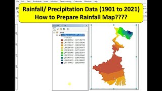
• Annual Average Rainfall Map in ArcGIS ||How to Download Precipitation Data: • Rainfall Map in ArcGIS || Annual Aver...
• How to Download GIS Shapefiles: • How to Download GIS Shapefiles || Sha...
• Direct Download of Slope Map, Roughness Map, Slope Aspect Map of Any Area: • Direct Download of Slope Map, Roughne...
• Projection & Coordinate system transformation of Raster || How to Change Coordinate System in ArcGIS: • Projection & Coordinate system transf...
• How to Create Study Area Map in ArcGIS | Creating Location Map of Study Area: • How to Create Study Area Map in ArcGI...
• NDBI in ArcGIS : • NDBI in ArcGIS || Normalize Differenc...