Grow your YouTube views, likes and subscribers for free

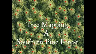
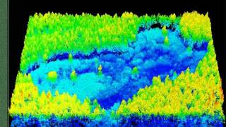
Next Generation of Forest Inventory Tools (LIDAR)

Gone are the days of foresters utilizing paper copies of aerial photos to assist in planning and navigating to sample plots. Now in combinations with geographic information systems (GIS), specialized equipped drones that for all extent and purposes and in some cases can are take the equivalent of magnetic resonance image (MRI) of a forest. @foresterdeano


Recommended