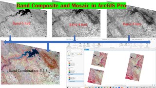
Oil and Hydrocarbon Index By landsat 8 data

Welcome to world Geography With M.adnan
today tutorial is relkated to "Hydrocarbon mineral oil location
Landsat satellite raster data can be used to identify subsurface oil deposits and the following band ratios are commonly used:
1. Band 7/Band 5 (SWIR/NIR): This ratio is sensitive to hydrocarboninduced alteration and is used to identify areas with potential oil deposits.
2. Band 5/Band 4 (NIR/Red): This ratio highlights areas with high reflectance in the NIR region, indicating the presence of oilrelated mineralogy.
3. Band 6/Band 5 (SWIR/SWIR): This ratio is used to identify areas with thermal anomalies, which can indicate subsurface oil deposits.
4. Band 7/Band 3 (SWIR/Blue): This ratio helps detect subtle changes in mineral composition and identify areas with high oil potential.
Specifically, the following band ratios are used for oil exploration:
1. Oil Index (OI) = (Band 7 Band 5) / (Band 7 + Band 5)
2. Hydrocarbon Index (HI) = (Band 5 Band 4) / (Band 5 + Band 4)
These band ratios take advantage of the spectral signatures of oilrelated minerals and the thermal properties of oil deposits to identify potential subsurface oil deposits.
Note that the effectiveness of these band ratios may vary depending on the specific geological context, oil type, and data processing techniques used. Landsat 8's Operational Land Imager (OLI) and Thermal Infrared Sensor (TIRS) provide valuable data for oil exploration.
Source Llama Chat bot AI