Old Butt Knob and Shining Creek loop - Shining Rock Wilderness NC

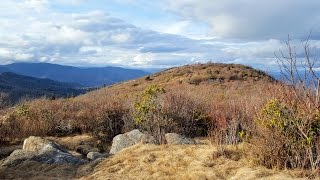
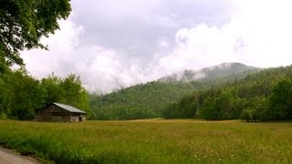
A hike on the northeast side of the Shining Rock Wilderness, tackling two new trails for me to two familiar summits. I parked at the Big East Fork Trailhead and followed the Shining Creek Trail to pick up the Old Butt Knob Trail. Multiple accounts place the Old Butt Knob Trail amongst the toughest trails in Pisgah National Forest. I don't think it's in my personal top 10, but I guess I understand the reasoning. The trail climbs straight up Chestnut Ridge, gaining ~1,400 feet in the first 0.9 miles. But after that it is pretty level once you reach 5,000 feet with a few minor climbs. There are two nice southern views from Chestnut Ridge and Old Butt Knob, and a possible view I missed from Dog Loser Knob. The campsites are plentiful here with lots of variety. Arguably the prettiest stretch of trail is between Dog Loser Knob and Shining Rock, with thick mountain laurels, heath bald meadows, and spruce.
My goal was to bag the true summit of Shining Rock (6,010 ft), which I missed last time I was here. I wandered around the massive heath bald summit, first checking out the whitest, prettiest white quartzite cluster. I found the summit on the east side, with wide open southeast views of the Blue Wall, Hickory Nut Mtns, Mt. Pisgah and Fryingpan Mt, and the Black Mtns. I found another view on the west side looking at Richland Balsam and the Plott Balsams, with the Great Smokies beyond. I finally stumbled on the massive southwest quartzite cliffs with views south of Grassy Cove Top and Black Balsam Knob, plus a great view of Fork Mountain massif with High Top and Birdstand Mountain.
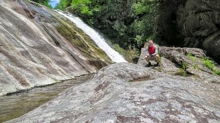
After spending more than an hour exploring Shining Rock I quickly headed south on the Art Loeb Trail towards Grassy Cove Top. The stretch around Flower Gap was beautiful as always. I finally took a snack break at the view from Grassy Cove Top (6,055 ft). The sun started poking out again, making it tough to get decent pictures southwest. From the rocks I admired the view of Graveyard Fields before turning around. To complete the loop I took the Shining Creek Trail down, which to me was very rough, rocky, and wet from all of the snowmelt. I think this trail might be tougher than the Old Butt Knob Trail. It was getting dark and I didn't pause much, but I counted at least 4 uninteresting slide waterfalls on North Prong Shining Creek. Near the end I spied a nice waterfall on Daniels Cove a few hundred feet above the trail. The main drop is around 20 feet, but the base was marred by big logs. With lower flow it probably is tough to notice it from the trail.
Hike was 11.9 miles in 7 hours and 45 minutes.
Hike location
https://goo.gl/maps/MNJXBhftvbcMdtoJ7
Hike report
https://www.hikingupward.com/PNF/OldB...