Old Train Maps: The Many Routes of California’s Central Pacific Railroad
Michele Tobias, University of California Davis DataLab https://datalab.ucdavis.edu/
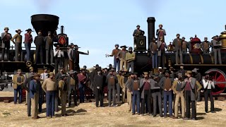
The Central Pacific Railroad, a section of the Transcontinental Railroad, runs from Sacramento, CA, to the CaliforniaNevada border just north of Lake Tahoe, but its current location was not the original plan. How did the route of the Central Pacific Railroad evolve from a plausible engineering concept, to the busy, asbuilt track it is today? In this talk, I will describe the how a team comprised of a geographer, hydrologist, and chemist found and georeferenced 21 historical maps of varying size, scale, and coverage from three time periods in the mid to late 1860s, then digitized the planned and built routes of the railroad to investigate just why the Central Pacific Railroad ended up where it did. I will discuss the workflow which relied heavily on QGIS and the specific issues our team encountered working with historic railroad engineering maps.
Links:
* Stanford's scanned copy of Judah's 1861 vellum map: https://searchworks.stanford.edu/view...
* California Museum's MAKING THE GRADE: CALIFORNIA & THE TRANSCONTINENTAL RAILROAD exhibit: https://www.californiamuseum.org/exhi...
* California Railroad Museum's exhibits celebrating the 150th anniversary of the transcontinental railroad: https://www.californiarailroad.museum...