Grow your YouTube channel like a PRO with a free tool

Part 3 Urban u0026 Land Cover Mapping - ArcGIS

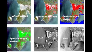
Urban Mapping and Land Cover Mapping
Landsat imagery + ArcGIS
Bands combination
Clip
Supervised classification
Image samplings
Latitude and longitude calculations
Area calculations
Map layout
——————————————————————


Recommended