Perform Flood Detection using Sentinel-1 SAR Imagery u0026 Calculate Area in Google Earth Engine

Join us as we explore the stepbystep process of flood detection using Sentinel1 SAR imagery in Google Earth Engine, with a focus on the Chennai area. This comprehensive tutorial covers everything from importing and setting up data to identifying flooded areas and calculating the affected area in square kilometers.
We'll start by importing administrative boundaries and defining the date ranges for the periods before and after the flood event. Our area of interest (AOI) will be Chennai, which we'll filter from the administrative boundaries and add to our map.
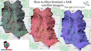
Next, we'll filter the Sentinel1 SAR data to obtain images in the IW (Interferometric Wide) instrument mode, with VH polarization, descending orbit pass, and 10meter resolution within our AOI. We'll explain the importance of using different wave polarizations, such as VV and VH, for detecting various phenomena.
We'll then split the data into two collections based on the defined date ranges—before and after the flood event. By creating mosaics and clipping them to the AOI, we'll generate clear before and after flood layers to analyze.
The key part of our tutorial is calculating the differences between the before and after flood images. By applying a threshold to the difference image, we'll identify flooded pixels and visualize the floodaffected areas with a distinct blue palette.
Finally, we'll calculate and print the total district area and the flooded area in square kilometers, providing a clear quantification of the flood's impact on Chennai.
Whether you're new to remote sensing or looking to enhance your skills, this tutorial simplifies the complex process of flood detection using Sentinel1 SAR imagery and Google Earth Engine. Follow along to gain valuable insights and practical knowledge for your flood monitoring projects.
Resources:
Sentinel1 SAR GRD: Cband Synthetic Aperture Radar Ground Range Detected:
https://developers.google.com/earthe...
FAO GAUL 500m Simplified: Global Administrative Unit Layers 2015, SecondLevel Administrative Units:
https://developers.google.com/earthen...
If you find this video helpful, please like, share, and subscribe for more tutorials on remote sensing and geospatial analysis!
Join Membership to get access to perks & Support us
/ @terraspatial
Join the Terra Spatial Community:
Engage with fellow learners, share your experiences, and get support on our dedicated community forum.
Stay connected:
Subscribe to our Channel: / @terraspatial. .
Facebook: / terraspatial
Geosuite blog: https://geosuite.blogspot.com/
**Don't forget to Like, Share, and Subscribe for more insightful tutorials! ✨
#FloodDetection #GoogleEarthEngine #Sentinel1 #SARImagery #RemoteSensing #GeospatialAnalysis #ChennaiFloods #EnvironmentalMonitoring