Polygon Neighbors Tool ArcGIS

Polygon Neighbors Tool, Proximity Toolset, Analysis Toolbox
summary
Creates a table with statistics based on polygon contiguity (overlaps, coincident edges, or nodes).
Usage
The tool analyzes polygon contiguity, summarizing the
Area of overlaps (overlapping neighbors—optional)
The length of coincident edges (edge neighbors)
The number of times boundaries cross or touch at a point (node neighbors)
between source polygons and neighbor polygons. The summary information is written to an output table. A source polygon may have one or more neighbor polygons; a neighbor polygon is spatially related with the source polygon in at least one of the above ways.
Only firstorder contiguity is analyzed and reported by the tool; relationships beyond that are not examined; that is, neighbors of neighbors (secondorder contiguity) are not examined.
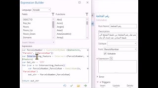
The Report By Field(s) parameter (in_fields in Python) is used to identify unique polygons or polygon groups and report their neighboring information by the polygons or polygon groups. To find the neighbors of each individual polygon in the input, specify one or more input fields that result in a unique value or set of values (in the case of using multiple fields) for each polygon.
Tip:
Calculating area overlapping relationships is a highresource operation, and performance could be much slower than determining coincident edge and node neighbor relationships. If you know your data has no overlapping features or you are not concerned about analyzing overlapping neighbors, be sure the Include area overlap check box is not checked on the tool dialog box (area_overlap="NO_AREA_OVERLAP" in Python).
Caution:
The Include area overlap check box must be checked in the dialog box (area_overlap="AREA_OVERLAP" in Python) to obtain records for neighbors that are completely contained by a source polygon. If you do not have the Include area overlap check box checked, the output table will not contain records for neighbors that are completely contained in a source polygon.
There is no entry in the output table for features that are not neighbors.
The Include both sides of neighbor relationship check box on the tool dialog box is used to control the relationships included in the output. To report all contiguity relationships, including reciprocal relationships, check Include both sides of neighbor relationship (both_sides="BOTH_SIDES" in Python). For example, if OID1 is a neighbor of OID2, an entry is written to the output table for OID1 having a neighbor OID2 and for OID2 having a neighbor OID1. If you only want the first side of the relationship, uncheck Include both sides of the neighbor relationship. Using the example above, but with Include both sides of neighbor relationship unchecked, only the entry for OID1 having a neighbor OID2 is entered into the output table.
Output Linear Units specifies the units to use for shared boundary length between neighbors. The default is to use the same units as defined by the input feature coordinate system.
Output Area Units is only used when the Area Overlap parameter is checked (area_overlap="AREA_OVERLAP" in Python). When Area Overlap is checked, the units used to calculate the area overlap of neighbors are specified in the Output Area Units parameter. The default is to use the same units as defined by the input feature's coordinate system.
The Output Table can be a file geodatabase table, personal geodatabase table, or .dbf table.
polygon neighbors ,polygon ,nearest neighbor ,polygons ,natural neighbor ,voronoi polygons in arcgis ,arcgis tools ,thiessen polygon ,select by polygon ,average nearest neighbor ,adjacent polygons ,arcgis geoprocessing polygons ,create thiessen polygon ,arcgis basic tools for beginners ,geoprocessing tools ,analysis tools ,how to use arcgis tools ,basic gis tools ,basic geoprocessing tools ,arcmap borders ,arcgis toolbox ,how dissolve tool works in arcgis:
Explanation of the tool:
https://gisforwe.blogspot.com/2021/08...
Follow the GISforWE website here:
https://bit.ly/GISforWE
A site for anyone interested in the field of GIS from here:
https://gisforwe.blogspot.com/
Proficiency in dealing with geographic data through ArcGIS programs:
• احترف التفاعل مع البيانات من خلال برا...
Learn the basics of creating geodatabases from here:
• أساسيات بناء قواعد البيانات الجغرافية...
Here is a page and a group on Facebook to learn more about Geographic Information Systems (GIS) and ArcGIS programs through these links:
ArcGIS Facebook group:
/ 486795389231905
Facebook group GIS for WE ArcGIS:
/ esri.arcgis
GIS for WE Facebook page:
https://www.facebook.com/profile.php?...
Video link for an introduction to learning on ArcGIS programs in three stages:
• مقدمة دورة تعلم ArcGIS بثلاثة مراحل |...
#ArcGIS
#Analysis_GIS
#Data_Analysis
Ramallah Palestine.
#GISforWE
GIS for the World of ELearning