Predictive Modeling of Flood Risks in the Philippines Manila Bay video using GEE

Welcome to our latest geospatial analysis showcase!
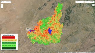
In this video, we delve into the world of predictive modeling to assess flood risks in the iconic Manila Bay area of the Philippines. Using the powerful capabilities of Google Earth Engine (GEE), we simulate hypothetical flood scenarios based on Sentinel1 and Landsat imagery data.
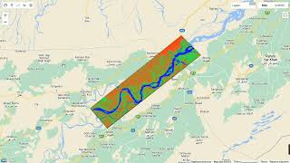
Through a series of geospatial techniques, we analyze historical Sentinel1 radar data to detect water bodies and visualize potential flood extents. Leveraging Landsat imagery, we provide insights into the evolution of flooding over time, offering valuable information for disaster management and urban planning.
Join us on this journey as we demonstrate how remote sensing and predictive modeling can contribute to understanding and mitigating flood risks in coastal regions like Manila Bay. Our goal is to raise awareness and empower decisionmakers with the tools and insights needed to build resilient communities in the face of environmental challenges.
Don't forget to like, share, and subscribe to our channel for more insightful geospatial analyses and tutorials using Google Earth Engine!
#FloodRisk #Philippines #ManilaBay #GoogleEarthEngine #GeospatialAnalysis #RemoteSensing #GIS #PredictiveModeling #DisasterManagement #UrbanPlanning #DataScience #EarthObservation #ClimateChange #Resilience #CommunityBuilding #DataVisualization #YouTubeScience #GIScience #Education #Technology #Innovation
e!


![The moment we stopped understanding AI [AlexNet]](https://i.ytimg.com/vi/UZDiGooFs54/mqdefault.jpg)