Sub4Sub network gives free YouTube subscribers

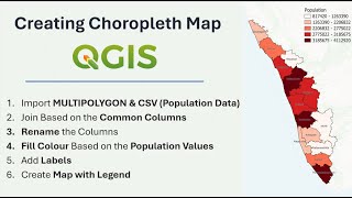
Prepare Elevation Map with Contour Lines in QGIS | Latest Tutorial

Download the Vector Polygon (Shapefile) & DEM Raster Layer: https://drive.google.com/drive/folder...
How to Extract Shapefile (Vector Polygon) of any Area: • Creating Shapefile and Study Area Map...
This tutorial will help you visualize topography using NASA's SRTM Digital Elevation data. Follow along as we import vector polygons, clip raster layers, apply topographical color palettes, extract contour lines, and create a comprehensive map complete with scale, coordinates, legend, and a north arrow. Let's dive in and bring your geospatial projects to life!


Recommended