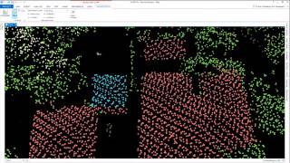
Processing LiDAR Data to extract 3D Buildings extract Roof Forms u0026 to classify Power Lines

Case Details: Elaborate video explaining Airborne LiDAR Data Processing using Esri ArcGIS Pro.(Watch in 1080p). LiDAR (Light / Laser Imaging, Detection & Ranging) data can be generated from instruments attached to:
a) Airborne vehicles such as Aircraft & Drones,
b) Stationary Terrestrial Scanner installed at ground level or at a specific height, and
c) Mobile Terrestrial Scanners setup on a Vehicle
#lidar #mapping #gis
Three distinct LiDAR data processing workflows covered
extracting 3D Buildings Footprint
extracting Roof Forms (extension to Footprint workflow)
classifying Power Lines using Deep Learning framework
Datasets & Processing Workflow Credit: Esri Learn ArcGIS
Video is part of Mapmyops Geoblog's elaborate article 'From Point to Plot : LiDAR & Processing its Data' which can be accessed from https://www.mapmyops.com/lidardatap...
Intelloc Mapping Services | Mapmyops.com is engaged in providing mapping products & services to organizations which facilitate operations improvement, planning & monitoring workflows. These include, but are not limited to Supply Chain Consulting, Drone Services, Subsurface Mapping, GIS Applications, Satellite Imagery Analytics & Polluted Water Remediation. Projects can be conducted panIndia. Connect with us [email protected]
Video is narrated by Arpit Shah Founder and Partner Intelloc Mapping Services
Read our published content from Mapmyops' Geoblog https://www.mapmyops.com/geo'>https://www.mapmyops.com/geo
Watch Mapping Solutions Use Cases on my website's home page https://www.mapmyops.com or from this YouTube channel.
Music from #Uppbeat (free for Creators!):
https://uppbeat.io/t/yetimusic/sprin...
License code: URQYYS0SC2BS7X1B
Music from #Uppbeat (free for Creators!):
https://uppbeat.io/t/walz/name
License code: 9ZDP5XA2UTLOXAIK
TIMESTAMPS:
00:00 Headline
00:05 Case Details
00:19 Caselet 1 Extracting 3D Building Footprint from LiDAR Imagery Dataset
00:23 C1 Workflow 1 : Setting up & exploring the dataset
03:43 C1 Workflow 2 : Classifying the LiDAR Imagery Dataset
10:44 C1 Workflow 3: Extracting Buildings Footprint
14:12 C1 Workflow 4: Cleaning up the Buildings Footprint
17:25 C1 Workflow 5: Extracting 'Realistic' 3D Building Footprint
20:47 Caselet 2 Extracting Roof Forms from LiDAR Imagery Dataset
20:51 C2 Workflow 1 : Setting up the Data & Creating Elevation Layers
30:16 C2 Workflow 2 : Creating 3D Buildings Footprint
33:54 C2 Workflow 3 : Checking Accuracy of Building Footprints & Fixing Errors
42:06 Caselet 3 Classifying Power Lines using Deep Learning (DL) on LiDAR Imagery Dataset
42:10 C3 Workflow 1 : Setting up and Exploring the Dataset
46:23 C3 Workflow 2 : Training the DL Classification Model using a Sample Dataset
51:31 C3 Workflow 3 : Examining the Output of the SampleTrained DL Classification Model
53:27 C3 Workflow 4 : Training the DL Classification Model using a Large Dataset
58:12 C3 Workflow 5 : Extracting Power Lines from the LiDAR Point Cloud Output
59:46 Summary Note & Contact Us


![The moment we stopped understanding AI [AlexNet]](https://i.ytimg.com/vi/UZDiGooFs54/mqdefault.jpg)