QGIS 101: Prepare the DEM - Mapping catchments u0026 streams from DEM - Part 1 of 3
Video 1 of 3, Mapping catchments and streams from DEM. In this video we will prepare a 30 m depressionless DEM of the Salma dam catchment in Afghanistan.
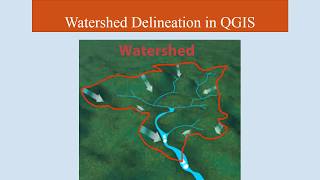
If we want to understand the water balance of a catchment or drainage basin, we need to start by delineating the catchment/watershed. In this threepart sequence we will prepare the DEM (Video 1), map the catchment/watershed (Video 2) and extract the streams (Video 3).
00:00 Terminology: catchment, watershed, drainage basin & drainage divide
00:49 Introduction
01:20 Location of Salma dam, Afghanistan
01:37 Step 1: Prepare the DEM
03:11 Use SRTMdownloader to locate the DEM tiles
03:35 Build virtual raster mosaic DEM tiles
04:28 Copypaste the raster style
04:50 Raster coordinate issues
05:52 Raster Projections Warp (Reproject) raster & resample pixel size
07:55 Save raster as GeoTiff
09:00 Step 2: Burn the streams
09:25 GRASS Raster r.carve
10:49 Step 3: Fill sinks
11:23 GRASS Raster r.fill.dir
Link to Video 1: • QGIS 101: Prepare the DEM Mapping c... (THIS VIDEO)
Link to Video 2: • QGIS 101: Map the Catchment Mapping...
This video is part of the online QGIS 101 training course.
For more QGIS videos see the QGIS playlist: • QGIS 101
#filledDEM #rcarve #rfilldir


![The moment we stopped understanding AI [AlexNet]](https://i.ytimg.com/vi/UZDiGooFs54/mqdefault.jpg)