Sign In
Home
Popular
News
Popular now
New music
Cute animals
Trending today
Hot trailers
Popular music
Comedy clips
New tech
Popular sports
Learn new
15 Free YouTube subscribers for your channel
Animals
Babies
Beautiful
Cats
Creative
Cute
Dogs
Educational
Funny
Heartwarming
Holidays
Incredible
Inspirational
Interesting
Love
Music
Nature
Oops
Performance
Pranks
Science
Sports
Technology
Unexpected
Best Cat Humor
Watch Dog Videos
Cover Song Charts
QGIS: Advanced Geoprocessing
Back
Follow
Advanced Geoprocessing with QGIS.
QGIS:
http://qgis.org
posted by
Katalpa4h
[ f ] Share this video on Facebook
QGIS: Understanding and Using Attribute Data, Queries, and Analysis
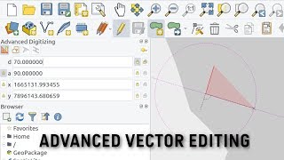
QGIS User 0006 Advanced Editing QGIS3
QGIS: clipping
QGIS: Attribute Tables and Selecting Features
Introduction to Geoprocessing in QGIS (Buffer and overlay)
Developing a 3D Model using QGIS
Extracting Data from OpenStreetMap using QGIS & QuickOSM
Putin resorting to ‘Soviet era’ weaponry to cope against Ukraine | Maj Gen Chip Chapman
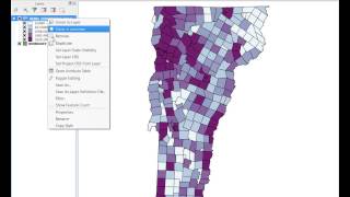
QGIS Quick Tips Analyzing Patterns
James Webb Space Telescope Just Received A Terrifying Signal From The Andromeda Galaxy
Joining excel to qgis
Build a Real Estate Marketplace Frontend Using Next.js 14, MapBox, Shadcn UI, and Tailwind CSS
Deriving River Network & Catchments from a DEM using QGIS
QGIS Layer Properties: Symbology and Labels
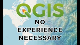
QGIS for Beginners
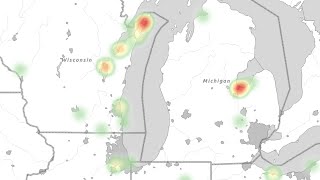
QGIS: Heat Maps
Putin’s chances of ‘significant gains eroded’ by oil depot strikes | Sean Bell
QGIS: Rulebased styles
Recommended
10 Signs You're Obviously Mad With Christmas!
05:11
The Most Annoying People on the Subway
07:11
I Can Do Better Prank Compilation
13:57
Are You Ready To Climb El Capitan Right Now?
04:48
Turn Your Phone Into A Hologram Projector Easily!
02:21
What Every Cat In The World Is Like
00:24
Best Way To Take A Nap While Walking
00:28