Rock YouTube channel with real views, likes and subscribers

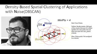
QGIS DBSCAN Cluster Analysis

A brief video using cluster analysis on a point layer, representing households, to identify potential settlements.
timestamps
0:00 Start
0:57 DBSCAN Clustering
3:23 Filtering for points in clusters
4:06 DBSCAN Clustering take 2
4:49 Minimum bounding geometry
QGIS https://qgis.org
SMS https://smsgis.co.za


![Hierarchical Cluster Analysis [Simply explained]](https://i.ytimg.com/vi/8QCBl-xdeZI/mqdefault.jpg)


Recommended