QGIS for groundwater applications

Register for the latest AWS QGIS ondemand Training Course: QGIS essentials for water modelling:
https://awschool.com.au/training/qgis...
Download this presentation slides here: https://awschool.com.au/resources
***Chapters***
00:00 Introductions & Polls
07:15 Preprocessing groundwater data in QGIS
23:08 Input data mobile app
24:21 Resources
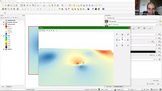
25:52 Visualising groundwater data in QGIS
35:17 Viewing a surface in 3D
38:40 Q&A
49:12 Wrapup
***Description*** Webinar number 107
Hear from Hans van der Kwast @ IHE Delft Institute for Water Education and Kurt Menke @ Septima, discuss preprocessing and visualising open data for groundwater analysis and modelling.
QGIS offers great tools for groundwater applications. Join this webinar to learn about the tools in QGIS for groundwater applications. Learn how to prepare data for groundwater analysis and modelling and visualise the results in 2D and 3D. This webinar will demonstrate a typical GIS workflow for hydrogeological studies:
1. Importing borehole data from various sources;
2. Sample elevation at the borehole locations from a DEM;
3. Interpolate groundwater levels of the boreholes to a raster;
4. 2D/3D visualisation of groundwater data.
These skills are fundamental for visualizing and analyzing groundwater data.
Some key takehome messages from this webinar include:
import QGIS data easily from CSV files and spatial data infrastructures;
correct borehole records that miss surface elevation data by sampling from a DEM;
create continuous rasters from borehole data from different interpolation algorithms in QGIS;
interpret the results of the interpolation using 2D and 3D visualisation.
What’s next?
This is an introduction to the live training course, beginning on the 6th May 2021, register here: https://awschool.com.au/training/qgis...