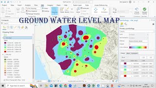
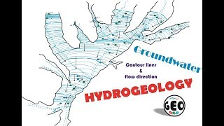
QGIS: How to create a groundwater contour map using the Thin Plate Spline (TPS) Interpolation

In this video I will show you how to quickly and easily interpolate a large groundwater level dataset using the QGIS Thin Plate Spline (TPS) Interpolation tool. We will create a smooth raster of the static water level data of the Tapi River Basin of India, and then create contour lines and groundwater flow direction arrows. Finally we will save the contours to a GeoPackage file and print a map to PDF using the A1 map template.
You will need to install SAGA if you are using the new versions of QGIS:
► Link to SAGA installation Manual (PDF): https://bit.ly/Install_SAGA_in_QGIS_W...
► Link to SAGA installation video: • How to install SAGA in QGIS No Bina...
Chapters
00:00 00:35 Introduction
00:35 01:11 Definition of groundwater levels
01:11 01:40 Thin Plate Spline interpolation method
01:40 02:33 Prepare the background map
02:33 03:54 Import static water levels
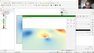
03:54 05:36 Thin Plate Spline interpolation
05:36 07:09 Extract the contours
07:09 07:25 Multipart to Singleparts
07:25 11:07 Edit contour line and label formats
11:07 13:24 Add groundwater flow direction arrows
13:24 14:32 Clip contours outside of the river basin
14:32 15:26 Inverted polygons to hide areas outside the basin
15:26 16:30 Export map to PDF
16:30 16:58 Final words
Link to Manual:
► https://bit.ly/3ghPUeI
Link to QGIS QML file for loading the 100m contour style:
► https://bit.ly/100mGWcontours
Link to reference papers:
► https://cseweb.ucsd.edu//~sjb/pami_tp...
► http://elonen.iki.fi/code/tpsdemo/ind...
For more videos on QGIS, see the QGIS 101 Playlist:
► • QGIS 101
#QGIS #ThinPlateSplineInterpolation #staticwaterlevelcontours