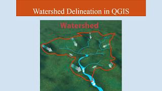
QGIS Lessons-4 Download DEMCreate SlopeAspectContourHillshede map u0026 Delineation of watershed
In this lecture we will learn How to Download DEM from USGS earth Explorer , SRTMCGIAR & from BhuvanNRSC also we will learn How to Mosaic DEM & Extract DEM then we will going to learn to How to Create Slope Map, Hillshede Map, Aspect Map, Contour Map & finally we will learn how to How delineate Watershed in QGIS.
Geotech GIS Training institute is a prestigious remote sensing training institute in India. Our vision is to bring an opportunity to every aspirant who dreams of a successful career in remote sensing and GIS field.
We conduct the following courses:
Training Program Related to Project Work Duration 1 Month
Basics of Remote Sensing and GIS Duration 3 Months
Advance Diploma in Remote Sensing and GIS Duration 6 Months
PG Diploma in Remote Sensing and GIS Duration 1 Year
Master of Remote Sensing and GIS Duration: 2 Years
Join our telegram Group
Remote Sensing & GIS Professionals :
https://t.me/joinchat/UhUorR2yhloKeKP...
lesson1: • QGIS Lesson1 QGIS absolute beginners...
lesson2 : • QGIS Lesson2 Digitization in QGIS, D...
Lesson3: • QGIS Lessons3 Interface of Google Ea...
Any Help Contact
Mr.Vikas [email protected]
WhatsApp Number= +918421031398
Mr.Aniket Borgawkar+919096244262, +919284471310
Email Id: [email protected]
Shivali Deshmukh Email Id:[email protected]