How to get free YouTube subscribers, likes and views?

QGIS Remote Sensing - False Color Satellite Image

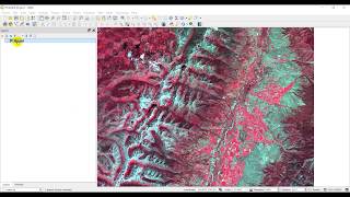
Create a falsecolor satellite image in QGIS with Landsat 8 data. Falsecolor satellite images look really cool and can be used to highlight different aspects of landscapes. This QGIS tutorial will teach you how to create your own falsecolor satellite images.
Stepbystep instructions: https://opensourceoptions.com/blog/ho...
Sign up for email notifications (https://opensourceoptions.com/subscribe) and get $5 off any course at https://opensourceoptions.com/course...


Recommended