Sub4Sub network gives free YouTube subscribers

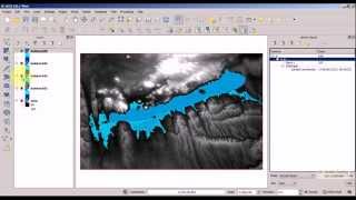
QGIS Tutorial 10/12: Regional statistics

The video presents the use of diagrams. First we load the prepared files (derived from OSM roads, railways shape file layers) and set visualisation (inverted polygons). Then we sum the thematic road segments in each county with Sum line length option. Finally the viewer can see the distribution of road types via pie charts and a normalized (according to area) cycleway indicator by histograms.


![The moment we stopped understanding AI [AlexNet]](https://i.ytimg.com/vi/UZDiGooFs54/mqdefault.jpg)


Recommended