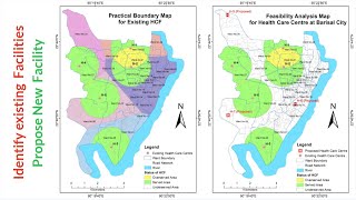
QGIS Tutorial - Create Buffers and Select/Identify Features within Buffers

QGIS is a powerful but free GIS tool for researchers and planners in many sectors who need geographic and spatial information to efficiently support their work. For transport planners, the most frequent function of QGIS is to draw a circle (buffer) centred at a specific point on a map with coordinates known, and identify which feature points are within the given buffer.
This is a handson tutorial to instruct beginners to quickly learn such skills and waste less time on filtering this useful content from other long QGIS tutorial videos.
There are two spreadsheets involved in this tutorial that can be requested from the author please drop an email to [email protected]. Otherwise you may create your own spreadsheets for your exercise that's way too easy.
The MMQGIS plugin cited in this video can be downloaded from QGIS official website: https://plugins.qgis.org/plugins/mmqgis/


![HandsOn Power BI Tutorial Beginner to Pro [Full Course] ⚡](https://i.ytimg.com/vi/5X5LWcLtkzg/mqdefault.jpg)