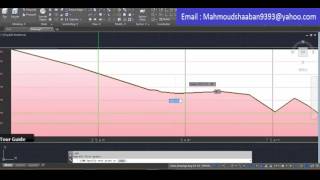
QGIS Tutorial: How to create Elevation Profile in QGIS [EN]

[QGIS for beginners] In this video, I will show you and explain step by step, How to create elevation profile in QGIS on windows 10.
==== QGIS ====
QGIS is a Free and Open Source software for use in Geographic Information System.
QGIS is the best alternative to commercial GIS desktop application such as ESRI ArcGIS (ArcGIS Pro), Hexagon erdas imagine, Geomedia MapInfo due to its user friendly interface. QGIS is the leading open source software, user friendly, cross platform and freely downloadable geographic information system desktop application that is licensed underneath GNU, and it helps viewing, editing, analysing of geospatial data and compliance with open geospatial consortium (OGC) standards.
==== Profile tool ====
This tool plots profile lines from raster layers or point vector layer with elevation field. Supports multiple lines as well as graph export to svg, pdf, png or csv file. Supports 3D polyline export to dxf.
============================
File: https://drive.google.com/file/d/1clUt...
============================
0:19 Download and install plugin
1:18 Import data
2:22 Using elevation profile plugin
============================
GIS4Dev : GIS for beginners
QGIS for beginners, QGIS tutorial, GIS tutorial, GIS web services tutorial, WMS tutorial, WMTS tutorial,
WFS tutorial, WCS tutorial, Google Earth Engine tutorial, ESRI ArcGIS tutorial, Postgresql tutorial, Postgres tutorial,
PostGIS tutorial, GeoServer tutorial for beginners, GeoServer tutorial, OGC, open source software, Google Maps, How to use Google Maps, Google Map tutorial
============================
Contact: [email protected]
Website: http://www.gis4dev.com
Facebook: / gis4dev101058764633058
Twitter: / pattrawuth4
LinkedIn: / gis4deva87714195
============================
Music Credit: www.bensound.com
============================
#qgis #elevation #profile #map #geo #geospatial #mapping #geography #spatial #opensource
![QGIS tutorial: Buffer Parameters [EN]](https://i.ytimg.com/vi/tSBedNDkwAw/mqdefault.jpg)
![QGIS Tutorial: Landsat 8 PanSharpening [EN]](https://i.ytimg.com/vi/tC8BeasDB5w/mqdefault.jpg)


![How to Download Digital Elevation Models (DEM) in QGIS [OPENTOPOGRAPHY]](https://i.ytimg.com/vi/FeM86Gz40_k/mqdefault.jpg)


![QGIS Tutorial: Clip raster [EN]](https://i.ytimg.com/vi/DIRImbUeYK8/mqdefault.jpg)