It was never so easy to get YouTube subscribers

QGIS2.18.28 cool features
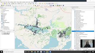
In this video, I will demonstrate how to load in a csv dataset, how to change the colors to show each individual animal's location, how to create heatmaps indicating areas of high density of locations, how to show lines indicating the path each individual animal took, and how to create MCP home ranges of any size (i.e., 50% vs 95%). This requires loading in 3 plugins (Animove, TimeManager, and Points2One) which is why we are using QGIS version 2.18.28 instead of the newest QGIS version.


Recommended