Radiometric Enhancement in Satellite imagery | Arcgis Tutorial | 100 Subscribers

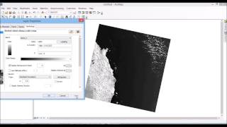
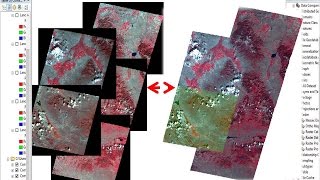
Radiometric enhancements are techniques that improve contrast between certain features by altering the screen colors assigned to specific ranges of pixel values.
In this video, I covered the Radiometric enhancement of satellite imagery using two different methods in ArcMap. I also looked at the options available for changing display in the image analysis window.
Subscribe to My channel for NEW VIDEOS EVERY DAY and make sure to enable Push Notifications so you'll never miss a new video.
All you need to do is PRESS THE BELL ICON next to the Subscribe button!
Download satellite image: • Download data for GIS specially Lands...
1:41 Image Analysis
4:26 Display Histograms
Learn ArcGIS software in this lecture series...
Check my Fiverr profile: https://www.fiverr.com/s2/df39f26a85
https://www.fiverr.com/s2/952b9deb55
Add me on Facebook https://facebook.com/profile.php?id=1...
Follow me on Instagram / kazialmuqtadir
Related tags: Radiometric Enhancement in satellite imagery,radiometric enhancement in landsat imagery,radiometric enhancement,radiometric enhancement in landsat 8 imagery,radiometric enhancement in arcgis,satellite image enhancement,image enhancement in remote sensing,image enhancement techniques,importance of image enhancement,image enhancement types,contrast enhancement methods,contrast enhancement remote sensing,contrast enhancements,Almuqtadir Abir
#radiometric_enhancement #satellite_image_inhancement #almuqtadir_abir