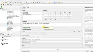
Raster data RECLASSIFICATION in QGIS 3

Reclassification is the process of reassigning one or more values in a raster dataset to new output values.
This could be due to finding out that the value of a cell should actually be a different value, for example, the land use in an area changed over time.
Let's see how to do a data reclassification in QGIS.
+++ What is QGIS?
QGIS is a professional GIS application that is built on top of and proud to be itself Free and Open Source Software (FOSS).
+++ Tales from the GIS?
Tales from the GIS is a geospatial journey into the fascinating world of Geographic Information Systems, telling you stories about nature and world.
+++Who am I?
Tales from the GIS is hosted by Eduard Roccatello. I love working on innovative solutions: things that change the status quo about spatial data development and usage. My day is full of math and big data. I like to be surrounded by interesting and skilled people. I really do care about user experience and software usability.
Music BenSound.com