REDD+ Learning Session 60: Estimating Forest Biomass using LiDAR Clouds

This is an archive of a session that took place on Wednesday, March 28, 2018.
You can download a copy of the presentation with reference information here: http://bit.ly/2DXr5fp
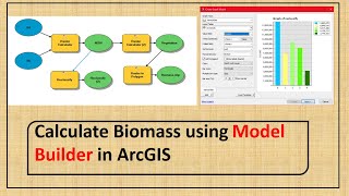
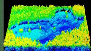
The biomass distribution inside a forest is an important measurement of its behavior and supports improved forest preservation and recovery strategies planning. Light Detection and Ranging (LiDAR) has been shown to be an extremely useful tool to estimate vegetation biomass, as it exposes the vertical profile of the trees and allows for the creation of a precise Digital Terrain Model (DTM). However, its use remains limited and a key barrier is knowledge about how to order LiDAR data.
In this learning session, Mr. Mauro Assis, from INPEBrazil, will explain how to plan a LiDAR collecting data campaign and use the collected point clouds to estimate forest biomass.