Regional Groundwater Modeling with MODFLOW and Model Muse

Now Hatariwater is Hatarilabs!
Please visit the new url of this post:
Please visit our site at:
www.hatarilabs.com
See our blog in this url:
https://www.hatarilabs.com/ihen/'>https://www.hatarilabs.com/ihen/
Download the required data for this tutorial on this link:
https://www.hatarilabs.com/ihen/'>https://www.hatarilabs.com/ihen/tuto...
Follow us on Facebook:
facebook.com/hatarilabs
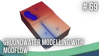
This video considers the construction of a regional groundwater model from scratch. Data entry will shapefiles and raster files.
Content
The video will include the following tasks:
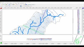
Grid generation from shapefiles
Aquifer and boundary condition conceptualization
Hydrogeologic units parametrization by shapefile
Import elevation from a AsterDEM
Recharge determination from precipitation rasters
Wetlands assessment form satellite images and model hydraulic heads
Groundwater water balance analysis
The agenda is interesting and applied for the study of groundwater at basin scale.
Requirements
This video is from intermediate level, there are some requirements to the participants:
Have installed MODFLOW with MODEL MUSE. Here is a link with instructions:
https://www.hatarilabs.com/ihen/'>https://www.hatarilabs.com/ihen/
Download the required data for this tutorial on this link:
https://www.hatarilabs.com/ihen/'>https://www.hatarilabs.com/ihen/tuto...