Remote Sensing Image Processing with Google Earth Engine Slope Correction Edge Otsu Algorithm

In this video, we'll delve into the fascinating world of remote sensing image processing using Google Earth Engine. Strap in as we explore the crucial techniques of slope correction, speckle filtering, and edge detection, unlocking the true potential of satellite images.
Overview of the Code:
The code, written in JavaScript for Google Earth Engine, empowers us with advanced functionalities. Brace yourself for a deep dive into slope correction, PeronaMalik speckle filtering, and edge detection using the powerful Otsu algorithm.
⛰ Slope Correction Algorithm:
Join me as we dissect the algorithm crafted by Andreas Vollrath, inspired by Johannes Reiche. Uncover the intricacies of radar geometry, terrain geometry, and model geometry, witnessing firsthand the transformative impact of slope correction on a Sentinel1 image.
Speckle Filtering with PeronaMalik:
Let's unravel the PeronaMalik algorithm for anisotropic diffusion. Understand how this technique preserves edges while filtering speckles, ultimately elevating the quality of radar images. Prepare for eyeopening visual comparisons between the original and filtered images.
Edge Detection using Otsu Algorithm:
Enter the realm of edge detection with the Otsu algorithm. Learn about automatic thresholding, Canny edge detection, and Otsu thresholding. Feast your eyes on intermediate results, such as binary thresholding and Canny edges, that pave the way for precise edge identification.
Parameterization and Customization:
Demystify default parameters and their pivotal role in the edge detection process. I'll guide you on customizing parameters to tailor the code to your specific needs, ensuring flexibility and adaptability.
Application on Sentinel1 Images:
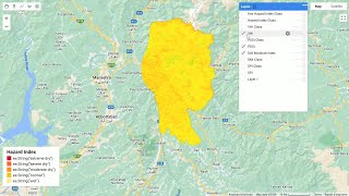
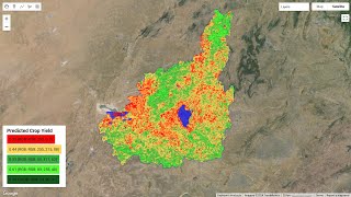
Watch as we put the code to the test on a Sentinel1 image collection. Visualize the results and witness the magic of edge detection in action. We'll showcase the final water segmentation, demonstrating the realworld applications of our remote sensing toolkit.
Conclusion and Call to Action:
Recap the key takeaways from our journey into remote sensing image processing. I encourage you to get handson with the code in Google Earth Engine. Explore its applications for your own remote sensing projects and share your insights with the community!


![The moment we stopped understanding AI [AlexNet]](https://i.ytimg.com/vi/UZDiGooFs54/mqdefault.jpg)