San Gabriel Mountains

Acorn Trail Cabins Wrightwood CA
contact "Mandy" 1 (323) 7419652
For Pacific Crest Trail Water reports
https://pctwater.com/
Offline Map and Guide Application
FarOut
https://play.google.com/store/apps/de...
Offline Map and Guide
alltrails
https://play.google.com/store/apps/de...
Free download off line Maps
Google Maps
Welcome to 100 miles through hiking the San Gabriel Mountains during the winter season starting from Pasadena California at the Arroyo Seco Trail connecting to the Gabrielino Trail Head at JPL/NASA and Silver Moccasin Trail at the Upper Tujunga Canyon Short Cut Saddle. From Short Cut Saddle the Silver Moccasin Trail connects to the Pacific Crest Trail.
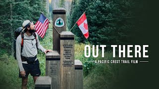
The Pacific Crest Trail
Is a National Scenic Trail with
2,650 Miles of discovery.
The trail starts at the Border of Mexico Southern Terminus Monument in Campo California traveling through three States California, Oregon, Washington ending at the Border of Canada Northern Terminus Monument in Manning Provincial Park.
for more information visit
https://www.pcta.org/