Satellite Image Processing (Part - 1) | Civil Workshop
This is a Certified Workshop! Get your certificate here: https://bit.ly/3xlOJA8
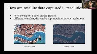
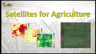
In this workshop, we will talk about “Satellite Image Processing ”. Our instructor tells us what remote sensing is, the physics behind satellite images, different types of satellite image processing, major satellite image processing systems etc. We also discuss the various career paths and job opportunities.
Visit our website for Job Leading Programs https://bit.ly/3f53hev
This is why you should choose SkillLync programs.
1. SkillLync is an elearning platform for Engineering students with 1000+ positive reviews on Google.
2. Learn industryoriented technical skills.
3. Work on 15+ Industry oriented projects. Create a strong profile that will help you get recruited.
4. Have a look at the profile of a student of ours https://bit.ly/32VE813
5. Attend live video conferencing support sessions every week.
6. Interact with industry experts and SkillLync support team 24/7 to get your doubts clarified
7. Get recruited with help from our placement assistance team.
Master's Certification Program in HighRise building Design & Analysis https://bit.ly/33ec3nI
Master's Program in Steel Structures https://bit.ly/31G5xWm
Masters Program in Bridge Design and Analysis https://bit.ly/3GeaDIz
Masters Program in STAAD.Pro for RCC, Industrial buildings and Metro Viaducts https://bit.ly/3rlVdvJ
To watch more such videos,
Subscribe to SkillLync Channel https://bit.ly/3sKWMpi and hit the to watch our videos first.
To know more about SkillLync, visit: https://skilllync.com/
We would love to stay socially connected with you. Follow us on:
Facebook / edxengine
Instagram / skill_lync
Twitter / skill_lync
LinkedIn / skilllync
#Satellite #SkillLync #Workshop #Engineering