Sentinel 1 Data Analysis with SNAP - SAR Interferometry for Earth Quake data visualization

Title: "Sentinel1 Data Analysis SAR Interferometry for Morocco Earthquake Data Visualization"
Description:
Welcome to our indepth exploration of Sentinel1 Data Analysis and SAR (Synthetic Aperture Radar) Interferometry, as we dive into visualizing seismic activity in Morocco. In this comprehensive 1000word description, we'll take you on a journey through the fascinating world of satellite technology and its critical role in understanding earthquakes.
Introduction:
Earthquakes are natural phenomena that have intrigued scientists for centuries. They result from the release of stress along geological fault lines, causing the Earth's crust to shift suddenly. While they are a natural part of our planet's dynamic processes, earthquakes can have devastating consequences for human populations. Understanding their occurrence, patterns, and potential impacts is essential for disaster mitigation and public safety.
Sentinel1 Satellites:
Enter Sentinel1, a series of Earthobserving satellites operated by the European Space Agency (ESA). These advanced satellites are equipped with synthetic aperture radar (SAR) instruments, capable of capturing highresolution images of the Earth's surface, regardless of weather conditions or daylight. This ability to "see" through clouds and darkness makes SAR data invaluable for monitoring geological events, including earthquakes.
SAR Interferometry:
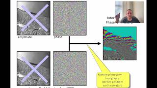
Now, let's dive into SAR Interferometry, a sophisticated technique that leverages the power of Sentinel1 data. SAR Interferometry, or InSAR, involves comparing multiple radar images of the same area over time to detect changes in the Earth's surface. By measuring minuscule shifts in terrain, InSAR can reveal ground deformation caused by a variety of factors, including tectonic activity.
Morocco's Seismic Activity:
Morocco, located at the convergence of the African and Eurasian tectonic plates, is prone to seismic activity. Recently on 8 September 2023 it was hit by 6.8 magnitude earth quake. The Epicenter was 44 miles southwest of Marrakesh, which is near the town of Adassil, in the High Atlas Mountains, Al Haouz province.
Data Collection:
Sentinel1 satellites pass over Morocco at regular intervals, capturing radar images of the entire country. These images are then processed to create precise interferograms, which are visual representations of ground deformation. By comparing interferograms taken before (30 Auguest) and after (11 September) an earthquake, scientists can identify areas where the Earth's surface has shifted.
Visualizing Earthquake Data:
One of the most exciting aspects of SAR Interferometry is its ability to create visually striking representations of ground deformation. These colorful interferograms, often resembling psychedelic works of art, provide critical insights into the extent and direction of ground movement during an earthquake.
Monitoring Ground Displacement:
SAR Interferometry allows us to monitor ground displacement with remarkable precision. It can detect even the slightest shifts, whether they are horizontal or vertical. This information is invaluable for assessing the potential risks posed by seismic events, helping authorities make informed decisions about disaster response and preparedness.
Scientific Insights:
Our exploration goes beyond eyecatching visuals. We'll delve into the scientific insights gained from SAR Interferometry, including:
Understanding fault behavior: InSAR helps us track the movement of fault lines, shedding light on their behavior and potential for future seismic events.
Earthquake forecasting: By monitoring ground deformation over time, scientists can make more accurate predictions about when and where earthquakes might occur.
Disaster preparedness: Armed with the data provided by InSAR, authorities can develop strategies to mitigate the impact of earthquakes on infrastructure and communities.
Conclusion:
In this video, we've only scratched the surface of the incredible world of Sentinel1 data analysis and SAR Interferometry for earthquake visualization in Morocco. Through satellite technology and advanced techniques, we gain a deeper understanding of the Earth's dynamic processes and how they affect our lives. Join us in this journey of scientific discovery as we unravel the mysteries of Morocco's seismic activity, one interferogram at a time.
Don't forget to like, subscribe, and share this video to spread the word about the fascinating world of SAR Interferometry and its vital role in earthquake analysis. Thank you for joining us on this educational adventure!
#moroccoearthquake
#sentinel
#interferometry