Learn how to get Free YouTube subscribers, views and likes

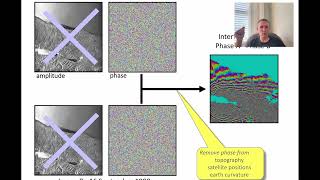
Sentinel-1 InSAR Coherence and Backscatter for Urban Area classification of Mogadishu

1. Search and Query an INSAR IW Sentinel1 pair
2. Preprocessing in SNAP: Split, Update Orbit, Coregister (Backgeocoding), Multilooking, Speckle Filtering, Range Doppler Terrain Correction.
3. Classification in ArcMap using the Image classification toolbar
4. Validation with ESRI Image Service


Recommended