Shoreline Change Analysis with DSAS v5.1 in ArcMap | Shoreline Change Analysis PART 2

Shoreline Change Analysis with DSAS v5.1 in ArcMap | Shoreline Change Analysis PART 2
DSAS V5.1 Download Link: https://code.usgs.gov/cch/dsas//tree...
About this Video
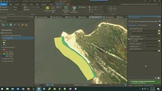
Welcome back to our Shoreline Change Analysis series! In this highly anticipated PART 2, we delve deeper into the process of calculating erosion and deposition at the shoreline using the powerful tool DSAS (Digital Shoreline Analysis System) v5.1 within ArcMap.
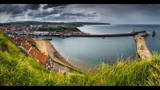
Understanding shoreline dynamics is crucial for coastal management and resilience planning, and DSAS provides invaluable insights by analyzing historical shoreline data. In this tutorial, we guide you through the stepbystep process of utilizing DSAS v5.1 to quantify erosion and deposition rates.
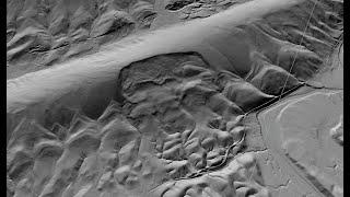
We'll begin by importing shoreline data and configuring DSAS parameters to suit our analysis objectives. Then, we'll demonstrate how to delineate reference transects and establish baseline shorelines for accurate measurement. With DSAS, identifying and analyzing shoreline changes over time becomes efficient and precise.
By the end of this tutorial, you'll have a comprehensive understanding of how to interpret DSAS results, including erosion and deposition rates, shoreline retreat, and accretion patterns. Armed with this knowledge, you'll be better equipped to make informed decisions regarding coastal development, habitat preservation, and risk mitigation strategies.
Whether you're a coastal manager, researcher, or GIS enthusiast, this tutorial provides invaluable insights into shoreline change analysis using DSAS v5.1 in ArcMap. Join us as we unlock the potential of geospatial analysis for coastal resilience and environmental management.
Don't forget to like, share, and subscribe for more geospatial tutorials and insights! Let's embark on this journey of understanding and safeguarding our coastlines together.
Uncertainty Calculation Excel sheet : https://bit.ly/3TbeqiM
#shorelines #changeanalysis #arcmap #dsas #gis #tutorial
Playlists ⬇
1⃣ Various Space Agencies & Missions: https://bit.ly/44UBJQI
2⃣ Data Download Processes for GIS Work: https://bit.ly/44WYP9D
3⃣ QGIS Basics Tutorials: https://bit.ly/3Oljo95
4⃣ ArcMap Basics Tutorials: https://bit.ly/3DoAopy
5⃣ Terrain Analysis: https://bit.ly/44UBJ38
6⃣ Hydrological Analysis: https://bit.ly/472LGgY
7⃣ Image Classification: https://bit.ly/3sb1iyR
8⃣ Indices: https://bit.ly/3RfKPUB
9⃣ Advanced Methods: https://bit.ly/3NRgt8H
The following geospatial and environmental solutions video instruction is available on this channel:
ArcGIS, QGIS (Geospatial Analysis, Monitoring)
Cartography
Basics of Mapmaking
Basics of GIS & Remote Sensing
You can watch our videos on YouTube : @dawnofgeospatialworld
If you think they're useful, kindly subscribe to our channel.
Instagram : / dogw_official
Facebook Group : / 1044628716532282
Thank you So Much.....