Shoreline Extraction from Satellite Image | Shoreline Change Analysis PART 1

Shoreline Extraction from Satellite Image | Shoreline Change Analysis PART 1
Description:
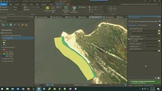
Welcome to Part 1 of our Shoreline Change Analysis series, where we delve into the fascinating world of shoreline extraction from satellite imagery. In this video, we'll explore the techniques and tools used to accurately extract shorelines from satellite images, laying the foundation for indepth shoreline change analysis.
Satellite imagery offers a powerful way to monitor changes in coastal environments over time, providing valuable insights into erosion, accretion, and other dynamic processes affecting shorelines worldwide. However, extracting accurate shoreline data from these images can be a challenging task, requiring specialized knowledge and advanced techniques.
Throughout this series, we'll cover various aspects of shoreline analysis, starting with the fundamental step of shoreline extraction. We'll discuss different methods, including manual digitization and automated algorithms, highlighting their strengths, weaknesses, and best practices.
Join us as we navigate through the complexities of shoreline extraction, uncovering the secrets hidden within satellite imagery and paving the way for comprehensive shoreline change analysis. Whether you're a researcher, environmentalist, or simply curious about the dynamics of our coastlines, this series is sure to provide valuable insights and practical knowledge.
Stay tuned for future installments where we'll delve deeper into shoreline change analysis, exploring topics such as longterm trends, impact assessment, and mitigation strategies. Don't forget to subscribe and hit the notification bell to be notified when new videos are released.
Let's embark on this exciting journey of understanding and preserving our coastal environments together. Thank you for watching, and we'll see you in the next video!
#shorelines #changeanalysis #gis #arcmap #tutorial #coastal
Playlists ⬇
1⃣ Various Space Agencies & Missions: https://bit.ly/44UBJQI
2⃣ Data Download Processes for GIS Work: https://bit.ly/44WYP9D
3⃣ QGIS Basics Tutorials: https://bit.ly/3Oljo95
4⃣ ArcMap Basics Tutorials: https://bit.ly/3DoAopy
5⃣ Terrain Analysis: https://bit.ly/44UBJ38
6⃣ Hydrological Analysis: https://bit.ly/472LGgY
7⃣ Image Classification: https://bit.ly/3sb1iyR
8⃣ Indices: https://bit.ly/3RfKPUB
9⃣ Advanced Methods: https://bit.ly/3NRgt8H
The following geospatial and environmental solutions video instruction is available on this channel:
ArcGIS, QGIS (Geospatial Analysis, Monitoring)
Cartography
Basics of Mapmaking
Basics of GIS & Remote Sensing
You can watch our videos on YouTube : @dawnofgeospatialworld
If you think they're useful, kindly subscribe to our channel.
Instagram : / dogw_official
Facebook Group : / 1044628716532282
Thank you So Much.....