Site Scan Webinar

What is Site Scan?
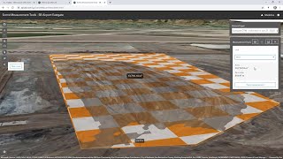
Site Scan for ArcGIS provides a comprehensive, endtoend drone mapping solution. It includes flight planning and fleet management tools that help you save time and keep drone operations running smoothly. It also lets you securely process drone imagery in a scalable cloud environment to create highquality 2D and 3D imagery products at scale. In addition, it provides analysis and measurement tools that streamline workflows like surveys and inspections. You can share drone products so they can be easily accessed on any device, helping you communicate with stakeholders and collaborate on projects.
What you will learn in this webinar:
In this webinar, you will learn more about the capabilities and features of Site Scan for ArcGIS. You will discover how Site Scan can help you to reduce drone capture time by streamlining the process of designing drone flight plans and conducting drone flights. You also learn how to gain insights from your drone imagery by extracting useful information, to better understand your areas of interest to support your business workflows and decisions.
About Esri Ireland:
Esri Ireland specialises in the application of geographic information systems, helping customers record where things happen and analyse why, with the aim of providing insight and helping them to make better decisions. As Esri’s official point of presence on the island of Ireland it has, since 2002, partnered with both the public and private sector to help them understand the impact of geography on their business.
Recognised as the #1 Best Workplace in Ireland (Small Business Category) & #22 in Europe's Best Workplaces, Esri Ireland is part of the Esri Global Network, a billiondollar privately held software company with over 10,000 employees worldwide.
Find out more about Esri Ireland via our corporate website (www.esriireland.ie) or discover our local presence via our ArcGIS Hub site (local.esriireland.ie).
Twitter: / esriireland
LinkedIn: / esriireland
Instagram: / esriireland