Snap Pour Point Tool ArcGIS

Snap Pour Point Tool, Hydrology Toolset, Spatial Analyst ArcToolbox
summary
Snaps pour points to the cell of highest flow accumulation within a specified distance.
Usage
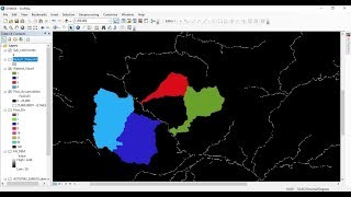
The Snap Pour Point tool is used to ensure the selection of points of high accumulated flow when delineating drainage basins using the Watershed tool. Snap Pour Point will search within a snap distance around the specified pour points for the cell of highest accumulated flow and move the pour point to that location.
If the input for point data is a point feature class, it will be converted to a raster internally for processing.
The output is an integer raster when the original pour point locations have been snapped to locations of higher accumulated flow.
When there is only one input for point location, the extent of the output is that of the accumulation raster. If there is more than one pour point location, the extent of the output is determined by the settings in the Output extent environment.
When specifying the input pour point locations as feature data, the default field will be the first available valid field. If no valid fields exist, the ObjectID field (for example, OID or FID) will be the default.
See Analysis environments and Spatial Analyst for additional details on the geoprocessing environments that apply to this tool.
pour point ,snap pour point ,point ,pour point in arcgis ,snap point ,pour points ,tools ,watershed creation using pour points in arcmap ,watershed delineation arcgis pour point ,point feature ,control points ,points ,delineate watershed by pour point , pore point ,how to cerate watershed using pour point ,delineation of watershed using pour point ,arcgis pro tools ,geoprocessing tools ,arcgis hydrology tools ,arcgis hydrology tools tutorial ,geospatial tools ,powerpoint
Explanation of the tool:
https://gisforwe.blogspot.com/2022/01...
Follow the GISforWE website here:
https://bit.ly/GISforWE
Lifetime download of ArcGIS and ArcGIS Pro software:
https://gisforwe.blogspot.com/2022/11...
https://gisforwe.blogspot.com/2021/05...
A site for anyone interested in the field of GIS from here:
https://exe.io/GISforWE
Proficiency in dealing with geographic data through ArcGIS programs:
https://exe.io/GISforWE1
Learn the basics of creating geodatabases from here:
https://exe.io/GISforWE2
Here is a page and a group on Facebook to learn more about Geographic Information Systems (GIS) and ArcGIS programs through these links:
ArcGIS Facebook group:
/ 486795389231905
Facebook group GIS for WE ArcGIS:
/ esri.arcgis
GIS for WE Facebook page:
https://www.facebook.com/profile.php?...
Video link for an introduction to learning on ArcGIS programs in three stages:
https://exe.io/GISforWE3
#ArcGIS
#Analysis_GIS
#Data_Analysis
Prepared and presented by the developer and researcher in the field of geographic information systems, Hossam Jubeh
Ramallah Palestine.
#GISforWE
GIS for the World of ELearning