Solo Camping The West Virginia Mountains
Welcome back for another amazing West Virginia adventure! Come along with me as we explore the beauty of the West Virginia wilderness. Dolly Sods is located within the Monongahela National Forest and is designated as a federal wilderness area. This is my fourth hiking and camping trip to the area and every trip still feels special!
As usual, I started by hike by parking at the Bear Rocks Preserve trailhead and began walking along Bear Rocks Trail. As soon as you start the hike, the beautiful mountain meadows of Dolly Sods are sprawled out in front of you. I was pleased to be greeting with beautiful blue skies and very moderate weather. The trails I hiked had long stretches of open sky with no tree cover, so I elected to wear my Mountain Hardwear sun hoodie to prevent getting fried.
After following Bear Rocks, I turned onto Raven Ridge Trail which is one of my favorite spots in Dolly Sods. The wide open meadows make for amazing views of the surrounding mountains and valleys, and I was pleased to see the mountain laurel was in full bloom. I briefly hopped off onto Valley View Trail to check out the biggest vista of the trip and take a short snack break. This was the only time I took off my Zpacks Nero 38L backpack for about ten minutes to take a break.
I took Valley View back onto Raven Ridge for a bit and then jumped on Big Stonecoal to make my push towards camp. I had originally planned to hike 1214 miles and make my way to a campsite at Red Creek. While hiking down Stonecoal, I quickly realized there were a ton of campers out that were already occupying sites. I figured it was in my best interest to set up my camp early for the night.
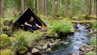
I found a nice little spot tucked into a spruce grove along a meandering creek. It was just large enough to set up my Warbonnet Blackbird hammock and shelter myself from the rain under my Hammock Gear dyneema tarp. I had enough room to work with to form a proper camp triangle, so I had a separate cooking area where I ate in my Helinox Chair Zero and was able to hang my food up the hill. There are black bears in the Dolly Sods area, so I typically take my food hanging seriously.
I started off early the next morning by taking Big Stonecoal to Rocky Ridge trail where my pace slowed considerably. I really like my Topo Athletics trail runners, but this is the one trail I sometimes wish I had boots every time I kick a rock with my toe. I followed Rocky Ridge until I hopped onto Red Creek Trail. Shortly after, I made my way to Red Creek to find there were a ton of people camped out from the previous night along the river banks. I'm glad I stopped early the night prior as it would have been chaotic to find a site.
I filtered some more water with my CNOC Vecto and Sawyer Squeeze and continued my hike up the only real elevation of the loop, then turned off onto Blackbird Knob trail. In the event any of you are wondering, Blackbird Knob isn't worth a summit. It's a bushwhack up the mountain with no view at the top, the only time I tried it I lost my shoe in the sucking mud. After a short jaunt, I turned off onto Upper Red Creek trail and made my way towards Dobbin Grade.
Upper Red Creek and Dobbin are two of my favorite trails in Dolly Sods. They have wide open meadow views just like Raven Ridge and Bear Rocks, but with the added challenge of insane mud. Luckily, I did a route that was new to me and minimized my time on Dobbin. I did have to do a pretty deep creek crossing where the water went up to my knees. Instead of slogging miles through the deep mud, I headed up the hill on Alder Run Trail, which turned out to be one of my favorite trails in Dolly Sods.
Alder quickly turns into Beaver Dam trail (aptly named) and it in turn proceeds back onto Dobbin, although you will have skipped the majority of the deep mud by then. I was happily swarmed by multiple groups of butterflies while hiking down this stretch of trail which was an awesome experience. I followed Dobbin to the end, turned right back onto Bear Rocks and headed towards the parking lot to complete the loop. As always, it was yet another amazing experience hammock camping the West Virginia Mountains!
Download the GPX file below from my Google Drive and pluge into your app of choice!
https://drive.google.com/file/d/1ORQq...
Check out my ten pound gear list!
https://lighterpack.com/r/rum8jk