Easy way to get 15 free YouTube views, likes and subscribers

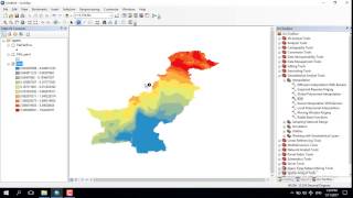
Spatial variability map using ArcGIS

Learn How To prepare a spatial interpolation map/ spatial variation map in ARCgis.
In the video we have used the Inverse distance weighting (IDW) tool available in ARCmap to prepare the interpolation map. IDW is a type of deterministic method for multivariate interpolation with a known scattered set of points.
Rainfall data used in the video was obtained from IMD.
this video don't have voice, so We have made a new video with voice. link to the new video is given below.
• IDW interpolation
For more such videos subscribe the channel.
/ gisquest


Recommended